This page outlines the geographic and natural context of Whiteside’s transformation of the landscape.
Often humans conceive of nature and the natural world as being separate or external to both themselves and human environments such as homes and city streets. The word nature evokes images of the tropical rainforest, the American prairie, waterfalls, the Grand Canyon, or wild animals. Rarely do these images include humans or human modifications such as cars or corn fields.1 Yet of course humans are a part of the Earth’s ecosystem, and to separate humans from it is to imply that human actions do not impact nature.
We also have the tendency to think of the natural world outside of human intervention, the “wilderness,” as timeless and static. The “wilderness” exists outside of history, and reality. It is instead a construct of human imagination. The environment is actually constantly changing, with and without human interaction, and not just at the usually slow pace of climate change or Darwinian evolution. It is a dynamic system constantly in flux. Entire forests grow and die off from disease, drought, and fire, with the population of animals and plants in those forests growing and shrinking as a result.2 Plants and animals change their behavior depending on the season. A mere 10,000 years ago, a blip in geologic time, the St. Louis region resembled the upper Great Lakes today: with forests of fir and spruce and a much cooler and wetter climate. Since then the climate has generally and gradually dried and warmed, but even the past 1000 years have seen relatively rapid climate shifts between warm and cool periods.3
Because ecosystems are so dynamic, it is incredibly challenging to untangle which changes are human-induced and which ones would have happened without them. A major component of my materialist argument is determining the changes brought about by Anglo-American settlers, yet as Cronon writes, any question of how humans change ecosystems inevitably leads to a second question, “changed in relation to what?” This is a much more difficult question to answer than at first glance. We cannot compare the ecosystem of Illinois of the early 19th century to how it would have been without Anglo-American settlement for obvious reasons: the latter did not happen. Thus is the problem of any “what if?” history.
An alternative inclination might be to compare to an “unspoiled wilderness” free from human impact; a “Virgin Land, the Forest Primeval, a wilderness which had existed for eons uninfluenced by human hands,” as Cronon writes. We might think this is the landscape Whiteside encountered in the 1780s, but, of course, the land had been already been modified by the French for a century and by Native Americans and their ancestors for millennia. Illinois ceased to be a non-human landscape when humans first arrived 10,000 years ago. By the time Europeans arrived, Native Americans had already transformed the landscape of North America to their purposes.
Thus, as Cronon writes, “The choice is not between two landscapes, one with and one without a human influence; it is between two human ways of living, two ways of belonging to an ecosystem.”4 To a certain extent my argument, like Cronon’s, will be a comparison between Native American and Anglo-American impact on the environment.
To remove humans from the natural world serves to remove nature from history, both ignoring how the environment has shaped human history and how human history has shaped the environment. If we are to understand how and why Anglo-American settlement transformed the ecosystem of the American Bottom, we must return humans to the natural landscape. As Cronon writes:
Our project must be to locate a nature which is within rather than without history, for only by so doing can we find human communities which are inside rather than outside nature.5
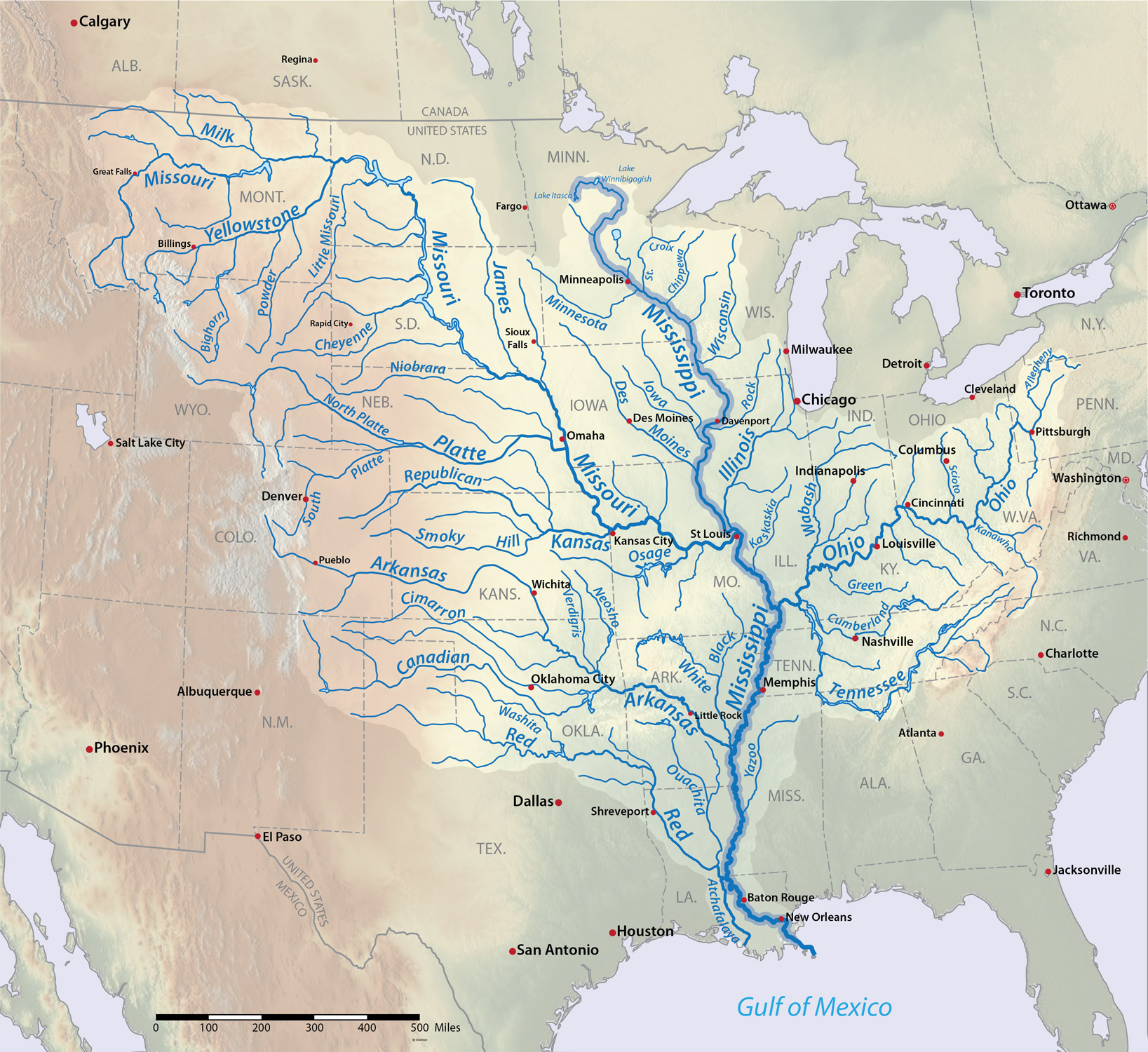
Both the history and geography of the St. Louis region is defined by rivers. It is the site of the confluence of three major rivers: the Missouri, Mississippi, and the Illinois. The united Mississippi drains the majority of creeks and rivers west of the Appalachian Mountains and east of the Rocky Mountains, reaching the ocean at the Mississippi Delta near New Orleans.

Thousands of years ago, the three rivers served to drain the meltwater of glaciers. In its four-and-a-half billion year history, the Earth’s climate has gradually cooled and warmed, as massive sheets of ice expand and contract from the northern and southern hemispheres. Particularly cold periods are known as ice ages or glacials, and the warmer times between them as interglacials.
During the past million years, the region has seen three glacials transform the landscape. Little is known of the earliest glacial that ended about a million years ago, as latter glaciers overrode the changes it brought. Half a million years later, the Illinoisan glacier crept into its namesake state, flattening and pulverizing the land. It only barely reached parts of Missouri, such as the future location of downtown St. Louis. There, the Mississippi and Missouri Rivers were blocked, forming a lake. Somehow this lake found a way to drain past the ice dam, either by forcing its way through the ice or draining around it. Lambert–St. Louis International Airport is located on part of the former lake bed.6
The Illinoisan glacier retreated 150,000 years ago, allowing the rivers to resume their course. As the climate warmed, it left behind a flattened Illinois landscape. As a result Illinois today, in general, is far flatter than most of Missouri.7 It also left behind rich glacial deposits of limestone and few large stones, making the land ideal for farming thousands of years later. However the Illinois glacier did not reach the state’s most southern regions.8

The most recent ice age began 50,000 years ago and ended 10,000 years ago. Though the Wisconsinan glacier never reached further south than northern Illinois, it impacted the St. Louis region. The climate was far cooler in St. Louis than today, and meltwater from the glacier and the emerging Great Lakes flowed down the Missouri, Illinois, and Mississippi Rivers. Far larger than today, the three rivers carried glacial meltwaters through the St. Louis region for thousands of years. With the glacial melt came greater volumes of sediment that easily dislodged from the unvegitated north. This gradually built up the three river plains, transforming gradual bluffs into vertical valley walls. At times the rivers stretched from the edge of the bluff to the other, leaving no floodplain.9
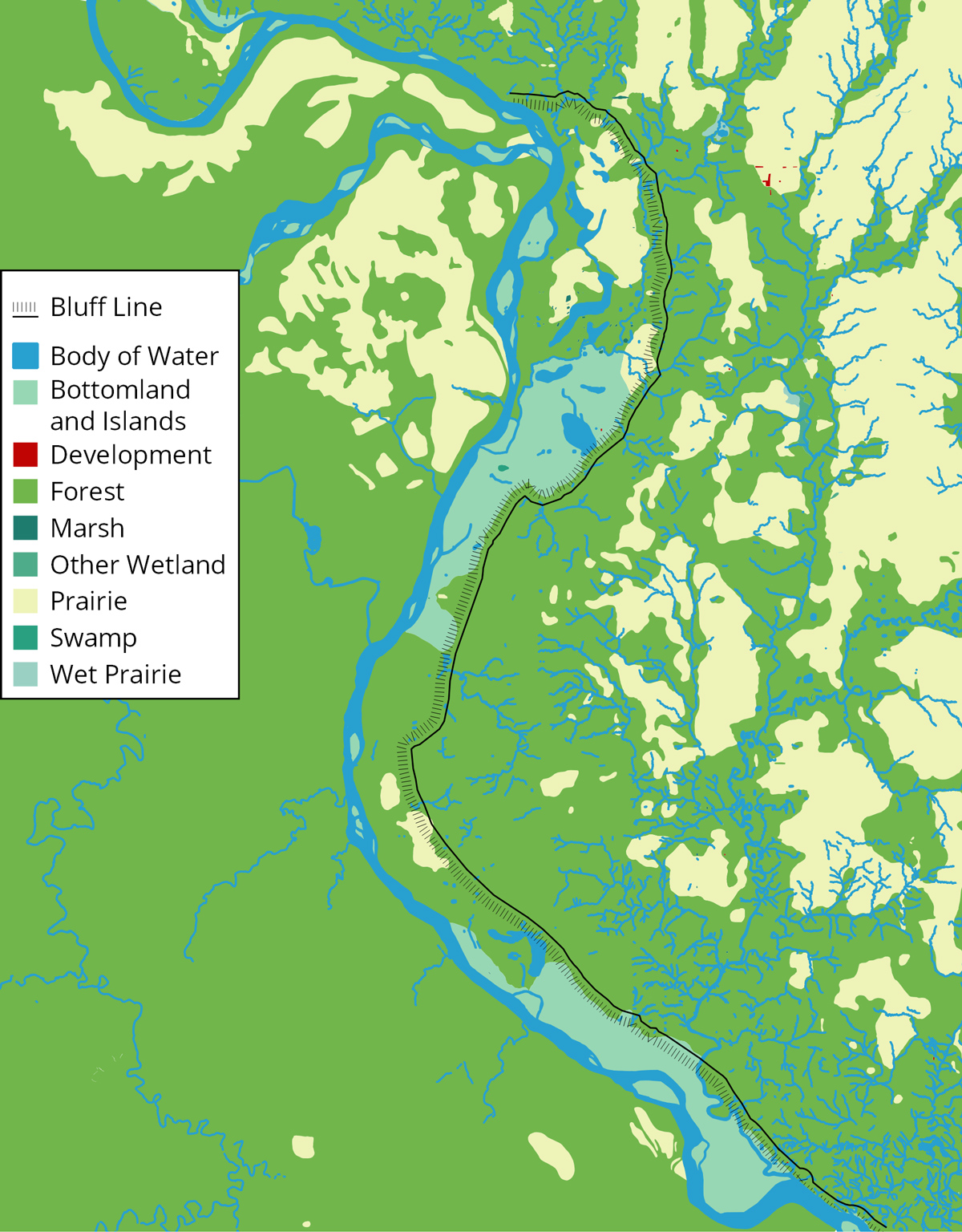
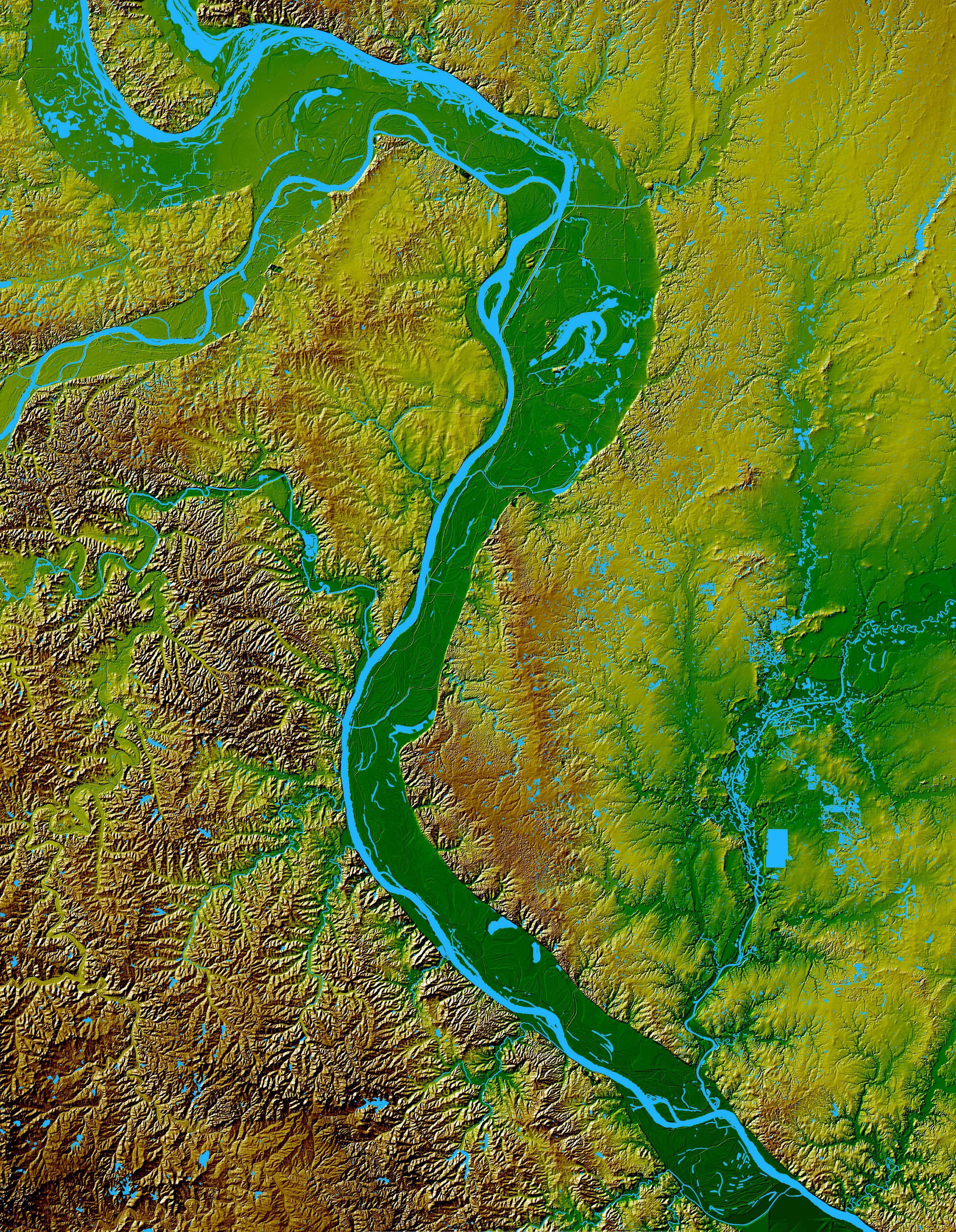
As the ice age ended and the glacier retreated, the rivers shrank and meandered. The narrower rivers, carrying much less sediment, carved into the previously thick valley. As they meandered back and forth across the river valleys, they smoothed and eroded away much of the built up sediment from the ice age.10 The Mississippi south of the confluence in particular meandered east and west across the valley, scouring out the floodplain. Today the river is located at the western side of the river channel, leaving behind a wide floodplain on the Illinois side of the river known as the American Bottom. Meanwhile the Missouri side is much higher immediately west of the river.11
When the Mississippi moved west, it left behind sections of the former river now cut off from flowing south. These former meanders in the American Bottom became lakes and marshes, along with creeks and streams that drained into the Mississippi. Horseshoe Lake near Cahokia Mounds is one of these former sections of the river. The American Bottom became a complex, interconnected system of inland waterways that frequently flooded.12
Immediately after each ice age, the recently glaciated American Midwest was left bare with little vegetation. Given further strength from a colder ice cap, powerful wind blew dirt and dust, known as loess, across the land like in the Dust Bowl of the 1930s. Loess was carried long distances and deposited in the St. Louis region, where tree roots and other vegetation captured it and prevented it from migrating. Thus nutrients from throughout the Midwest were deposited in the region. The rivers also carried loess from northern areas of the Midwest. As a result, the bluffs along the Mississippi are particularly thick with loess soil.
Loess is particularly rich soil for farming, and its frequency throughout the Midwest has made it one of the best regions in the world for agriculture. It is nearly as rich as alluvial soil of river bottoms without the risk of flooding. It is, however, very susceptible to both wind and water erosion when free from vegetation cover. This is exactly what occurred when Anglo-Americans converted the bluff lands from forests and prairie into farmland; water eroded the loess and flowed more rapidly into the Mississippi.13
Changes in climate did not just change the geography of the river valleys; it also had a major impact on plant and animal life. During the last ice age, the much cooler St. Louis region was largely covered by a spruce-fir forest, a biome similar to the upper Great Lakes region today. Following the last ice age was the dry and warm Hypsithermal period, which lasted from about 8,000 to 5,000 years ago (or 3,000 BCE). Animals and plants to the south and west migrated to the St. Louis region, transforming the spruce-fir forest to grasslands and forests of deciduous trees. Then the climate became moderately cooler and wetter between 3,000 and 1 BCE, moderating the climate to become similar to what it is today. This time northern species returned in larger numbers.
Even the past 2,000 years have seen fluctuations in climate. The Medieval Warm Period lasted from about 900 to 1200 CE, followed by the “Little Ice Age” from roughly 1450 to 1850.14 Since the 1950s, the Earth’s climate has been warming at rates unprecedented in the historical record, largely due to the increase in atmospheric carbon dioxide from the human burning of fossil fuels. Of course, this issue is highly politicized in the United States, though the vast majority of climate scientists believe both that the climate is warming and it is caused by human activities.15
Though the fluctuating climate over the past millennia changed the species composition of the St. Louis region, few species completely disappeared when the climate no longer suited them. Some adapted or found ecological niches or microenvironments to thrive in. Northern species could thrive near cool, moist sinkholes in warm periods, and southern species thrived in hot, dry, rocky glades in cool periods. Usually these niches are geographically isolated from each other, resulting in small, restricted populations of various species that favor different climates, relics of previous eras.
In other words, the St. Louis region is rich and biologically diverse today, and not only because of the variety of microenvironments. Located in the middle of North America and at the convergence of rivers, St. Louis is visited by species migrating from all cardinal directions, such as birds migrating up and down the Mississippi River valley every spring and fall or fish traveling through the rivers.
The biogeography of St. Louis is a borderland of many different species and biomes. Most broadly, it is located at a point of tension between prairie or grasslands of the west and woodlands of the east. Before European settlement, St. Louis and the American Bottom were a mixture of forest and prairie. Still, the dichotomy of forest and prairie is a simplification of an incredibly complex mosaic or patchwork of microenvironments arranged seemingly randomly on the landscape. These microenvironments could be as small as the difference between a north and south slope of the same valley.16
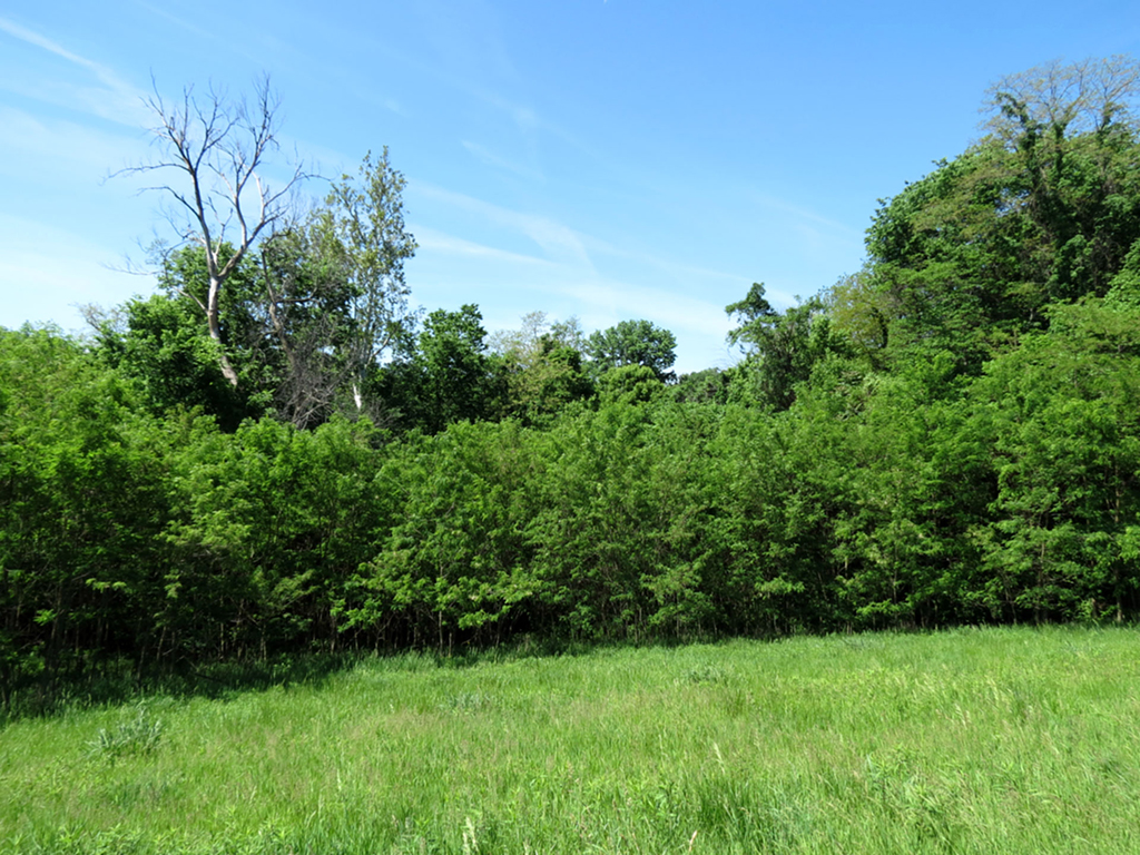
The American Bottom is the vast area of floodplain on the east side of the Mississippi near modern-day St. Louis. It runs about 100 miles north to south, from Alton to Kaskaskia. It varies in width from as narrow as four miles to as wide as ten miles between St. Louis and Collinsville. The bottomland is flanked to the east by bluffs, which vary from steep limestone cliffs 100 feet tall to gradual hills. The bluffs on Whiteside's property were the latter.17
Though the American Bottom floods much less frequently today thanks to modern engineering, it remains poorly drained. Lakes, marshes, and mud covered much of the American Bottom until the early 20th century. Modern water engineering through a complex series of dams, canals, dikes, and reservoirs has altered the nature of the rivers throughout the St. Louis region, dramatically reducing the seasonal variation of the rivers. Before the mid-twentieth century, the Mississippi flooded nearly every spring and early summer into the American Bottom.18 Still, flash flooding has become more frequent today, with paved streets and cleared forests allowing rain water to flow more freely instead of becoming absorbed into the ecosystem.19
The Mississippi also occasionally froze over during especially cold winters, which happened at least ten times between 1831 and 1938. My great-grandmother remembered walking across the frozen Mississippi in the early 20th century. River engineering today prevents the Mississippi near St. Louis from freezing over.20
Former meanders of the Mississippi and other wet areas of the American Bottom supported a variety of fish, waterfowl, and aquatic plants. Forests concentrated around these water sources, composed of cottonwood, willow, sycamore, maple, and hackberry, all pioneer trees. Old growth forests would not be able to develop due to flooding. Surrounding these riparian forests were wide areas of prairie.
Ascending the bluffs, the forests became denser, full of hardwood trees such as oaks and hickories, older forests protected from flooding. Cedar forests and occasional prairies covered the bluffcrests.21 Above the bluffs the landscape gradually flattens moving eastward; the prairies widen and the hills shrink.22 This upland landscape covered most of pre-Columbian Illinois, a relatively flat landscape largely of prairies, with forests concentrated near rivers and streams.
These prairies supported dozens of grass species, including big and little bluestem, side oats grama, Indian grass, and others. These tall grasses had roots that occasionally ran deeper than the grass above the surface, forming a root mat so dense that rainwater rarely ran deeper than six inches. As a result, few competing plants could take root amongst the grasses. These roots were a nightmare for the first European farmers that tried to cultivate prairie land, unable to cut through the roots with their iron plows. Still, the grasses produced perhaps the best farmland in the world, filling the soil with 150 tons of organic matter per acre of prairie. The deep roots also drew lime from rocks beneath the soil, reducing the acidity of the earth and improving its ability to support crops. Farmers were finally able to exploit this rich soil with John Deere’s steel plow in the 1840s.23

The American Bottom and the larger St. Louis region were once home to a wide variety of animal species, many of which are either gone or in far fewer numbers. Black bear, cougar, elk, gray wolves, wolverine, porcupine, and the passenger pigeon have all disappeared from Illinois, the last of which has gone completely extinct.24 Bison have only just recently been reintroduced on a northern Illinois wildlife refuge in 2014.25 Other animals remain but in far fewer numbers than in pre-Columbian times such as beaver, river otter, and trumpeter swan.24 Relatively common are bobcat, coyote, badger, moles, muskrat, opossum, skunk, red fox, various snakes, lizards, salamanders, owls, bald eagles, hawks, falcons, vultures, turkeys, voles, gophers, crayfish, frogs, and bats. More common are groundhogs, mallard ducks, white-tailed deer, raccoons, mice, rats, chipmunks, various bird species, various fish, frogs, toads, and turtles.
Most common of all today are squirrels, certain bird species, eastern cottontail rabbits, countless species of insects and spiders, and Canadian geese.26
Illinois today is also home to invasive animals brought by humans, such as stray dogs, cats, feral swine, the European starlings, house sparrows, rock pigeons, honey bees, some species of rat and mouse, and other escaped or released pets. With the exception of feral swine, pigeons, honey bees, rats, mice, and possibly dogs, none of these animals would have been present in Whiteside’s time.
Thus far I have been describing the natural setting of St. Louis without direct mention of humans. Yet it is difficult, if not impossible, to separate humans from the natural history of St. Louis, and much of what I have described was influenced, in part, by human activities.
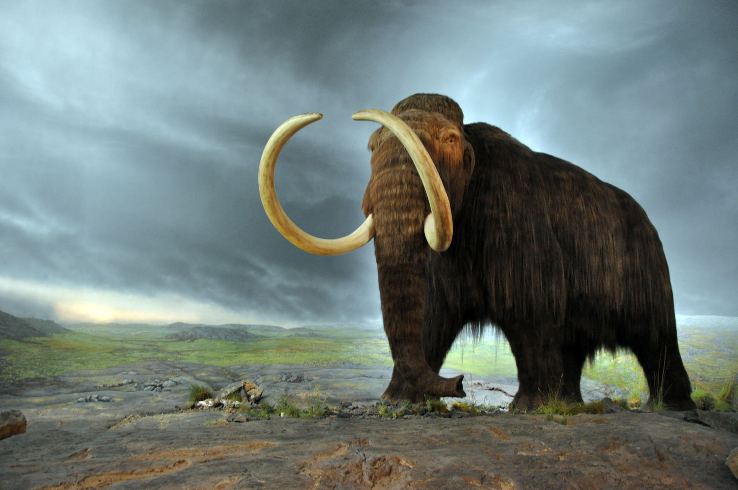
The first humans arrived in the area around when the last ice age ended, approximately 9500 to 8000 BC.27 Humans started changing the ecosystem as soon as they arrived in both subtle and dramatic ways. Their gathering of acorns and other seeds likely changed the distribution and frequency of trees and shrubs. Dramatically, they, along with the changing climate, drove large North and South American mammals to extinction; species such as the mammoth, mastodon, giant sloth, giant beaver, camel, long horned bison, peccary, wild horse, and musk ox.28
Any discussion of human environmental impact is usually primarily concerned with subsistence, the means by which humans provide for basic survival needs like food and shelter. Regardless of culture or class, all humans throughout history must eat, and the way they meet these basic needs largely determines their relationship to the environment. According to the materialist traditions of Marxism, subsistence is the basic pattern that ultimately defines all human activities.29
Throughout the vast majority of history over the past 100,000 years, humans have practiced hunting and gathering subsistence, much like other omnivores. This was true of the first PaleoIndians in the Midwest who hunted wildlife, fished, and gathered edible fruits and vegetables.
Gradually, people began to experiment with plant husbandry and domestication in the Midwest. Agriculture developed later than in the Middle East, but by 2000 BCE, Archaic Indians had domesticated and were cultivating a number of plant species, including squashes, gourds, and oily and starchy seed plants like sunflowers and marshelder. By about 600 BCE, the Woodland phase, they were also growing barley and tobacco. They likely grew these plants on forest soils in the uplands above the American Bottom, clearing garden plots with slashing and burning.30 Yet people did not cease to hunt or gather once they started cultivation. They relied on a variety of resource strategies.
The arrival of one grain in particular transformed the American Bottom more than any other: maize or corn. Originally domesticated in Mexico around 8,000 BCE,31 corn reached the American Bottom about 200 B.C. Initially it was only one crop among many, but by 800 CE, it had become a dominant food. Maize remains are found in 50 to 70 percent of archaeological features from after 800 CE in the American Bottom.

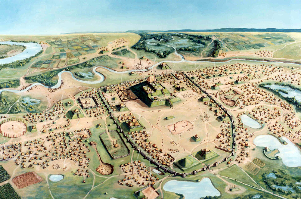
Corn was far more productive than any previously domesticated plant. Indians could grow more corn than they immediately needed, storing surplus for times of poor harvest. This could support larger populations and a more sedentary lifestyle. The subsistence strategies, economy, and entire society were transformed, beginning the Mississippian phase and the rise of Cahokia.32
Yet corn was not solely responsible for the rise of the Cahokian civilization. Numerous unknown political and social changes likely helped it form. In addition, the Medieval Warm period coincided with Cahokia’s height: 900 to 1200 CE. The warmer, wetter climate helped foster an agriculture revolution throughout upper North America of crops from Mexico: corn, beans, and squash. This trifecta of crops supported the Mississippian culture, a mound-building Native American civilization that settled throughout the Midwest and Southeast. Urban settlements and villages dotted the landscape, and the largest and most influential was Cahokia in the American Bottom.
Cahokia was likely the largest pre-Columbian population center north of the Rio Grande, considered a city by many archaeologists. No North American city outside Mexico would surpass its estimated population of 20,000 until Philadelphia in the mid eighteenth century.33 Cahokia and London had roughly the same population in 1086.34
The population was not restricted to Cahokia itself either. Numerous smaller suburbs were spread throughout the American Bottom and the future location of St. Louis. St. Louis was once home to 26 mounds and was known as Mound City, yet most of them were destroyed in the 19th century.35
Cahokia’s proximity to the confluence of three major rivers was no coincidence. Its economy relied heavily on trade, having connections to native groups near the Great Lakes, the southeast, and the Gulf of Mexico. Shells from the Gulf of Mexico have been found in the remains of Cahokia. Cahokians also imported ores like copper, lead, hematite, ocher, and flint, as well as salt.36
The large, sedentary population at the sizable trading center of Cahokia inevitably transformed the environment. Most visibly, Cahokians created the famous mounds, transporting and displacing massive amounts of dirt. The largest, Monk’s Mound, contains 22 million cubic feet of earth. The former sites of this earth became borrow pits, many of which became ponds or small lakes likely home to fish and other aquatic animals and plants. Others were possibly used as dumps for refuse and human waste. It is also possible Cahokians used smaller, individual household pits. In either case, the large amounts of waste, along with smog from cooking and heating fires, would have produced a very noticeable smell. Lewis and Clark were able to smell smaller Indian settlements from a distance during their voyage in the early 1800s.37
All of the people in Cahokia had to be fed, requiring vast and numerous fields for the cultivation of corn and starchy seed crops. Cahokians cleared much of the American Bottom’s forests and prairies for agricultural fields. Still, they were also reliant on wild plant and animals for food, so they likely left some areas for this use. Yet the habitats of many animals were lost, so Cahokians or a trade partner had to hunt deer at some distance away from Cahokia.38
Cahokia also required a great deal of wood for construction of buildings and the stockade wall surrounding the city’s center. Cahokia scholar William Iseminger estimates that the stockade wall alone required 20,000 logs, most of which came from the oak-hickory forests on the bluffs. The third and fourth bastions of the stockade were smaller than the first two, suggesting a reduction in available wood. Each house required about one hundred trees, and Cahokia had thousands of houses. Burning fires would have further reduced wood.
As would happen again when white settlers would clear the bluffs again centuries later, this deforestation left the soil unprotected from erosion. Floods became more frequent and possibly threatened crop fields in the American Bottom.39
The nature of Cahokia’s fall from power is not precisely known. Likely these environmental problems contributed to the civilization’s gradual collapse. Other environmental problems outside of Cahokians’ control also likely destabilized their society. The climate cooled as the Medieval Warming Period ended, shortening the growing season and making rainfall more sporadic. Thus both droughts and floods became more common. Evidence suggests the population shrank and moved to higher elevations between 1150 and 1250, probably due to higher water levels. As food became less available in Cahokia, new sources were becoming available elsewhere. Other communities grew a more resistant form of corn, Northern Flint, which Cahokia was slow to adopt, and beans, which Cahokia never grew. Greater numbers of bison may have also moved further east of the Great Plains around this time. Many Cahokians may have left to other communities where corn, beans, and bison meat were readily available.40
Political infighting or conflict with other groups may have also helped destroy Cahokia. In any case, the civilization did not disappear all at once and instead collapsed gradually. By the 1400s though, the Cahokia site was essentially abandoned.41
Though Cahokia had the largest environmental impact of any pre-Columbian Native American community in the region, later groups continued to modify the landscape.
Possibly the largest change they brought was the extension of prairielands eastward into the uplands of Illinois. Though known as the prairie state today, Illinois may not have had significant prairies without Native Americans. Without fire to clear trees, prairies tend to revert to forest in Illinois where precipitation is heavier than on prairies further west.42
The Prairie Peninsula, which stretched from western Iowa to western Indiana and included parts of Illinois, was created and maintained by prairie fires, the majority of which were likely started by Native Americans. Unlike in the dry west, natural fires started by lightning strikes are uncommon in Illinois, where conditions are too humid and lightning is usually accompanied by rain that puts out any fires lightning might start.43
Human-induced fires had occurred before Cahokia, but they became more common after the Little Ice Age began around 1450. Indians were still using them in Whiteside’s time.44
Native Americans set fire to the prairies and forests for a variety of reasons: clearing land for agriculture or travel, warfare, signaling, controlling and isolating fires, and hunting, particularly bison.45 A Frenchman, Father Hennepin, in 1680 observed Miami Indians in northern Illinois surrounding a herd of bison with a ring of fire with only one area open. The bison, trying to escape the fire, went through the one open area, where the Miami stood waiting for them. They killed scores of bison with their bows and arrows, enough bison meat and hide for a whole year. Thus the hunt was only conducted once a year.46
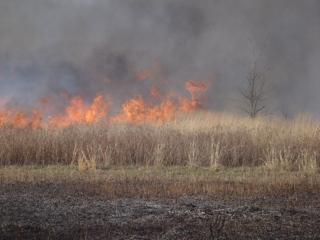
Native Americans likely realized that bison lived on prairielands and that fires were essential to the prairie, thus they also set fires to encourage ideal conditions for bison. Bison had lived in Illinois since the end of the last Ice Age, but their numbers vastly increased in Illinois in the 1500s as the prairies spread east from Native American fires.47
These fires also impacted the forests of Illinois. Woods were restricted to areas along ravines, rivers, streams, and hills, areas that acted as firebreaks.48 Fires made the forests less dense. Trees were spaced further apart and sunlight was better able to reach the forest floor. With access to the sun, vines, briers, and shrubs like hazel flourished in the understory of the forest. Hazel in particular thrived in fiery conditions. While fires burned hazel above the surface, its extensive root system allowed the plant to survive and sprout new shoots. Native Americans gathered nuts from hazel every fall, and also used its leaves and bark as a medicine. They likely noticed that fires encouraged the spread of hazel and other mast-bearing plants, and thus burned the forests as well as prairie. Without Indian fires and the active suppression of forest fires by modern fire departments, hazel has almost vanished from Illinois.49
Indian fires were not unique to Illinois. Native Americans throughout eastern North America burned forests, including in New England. There, fires had also made the forests less dense.50 However, prairies did not spread as far east as New England. The prairie peninsula, unlike New England, had low enough snow and rainfall to support a prairie ecosystem. Thus, the prairies of Illinois were the product of a combination of natural and human influences. Without Indian fires, the land was wet enough to support forests. With fire, the land was dry enough to support prairie.51
Even taking into account the extinctions of large North American mammals, the creation of the prairie peninsula, and even the erosion and overuse of resources by Cahokia, pre-Columbian Native Americans impacted the environment far less than Europeans and Anglo-Americans.
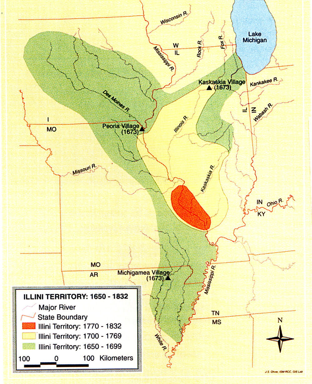
Generally Native Americans are conceived as living in harmony with nature. With the exception of Cahokia and possibly the earliest hunters of mastodons and wild horses, this was usually true. We must be clear about what “living in harmony with nature” means however. It does not mean that Native Americans did not impact nature; of course they did. The term “in harmony” is a reference to music, where two melodies complement or harmonize each other. In this last section I will demonstrate how Native American society generally served to complement the natural world. I will be using the two perspectives of Whiteside’s generation, materialism and ideology, to examine two tribes of Illinois: the Illini and the Kickapoo. The Illini had settlements along the Illinois River and in the American Bottom when the French made contact in the late 17th century. The Kickapoo lived in southern Wisconsin at that time, but European incursion forced them into central Illinois in the early 18th century.52

It is important to note that Native American cultures and beliefs can vary widely between groups, and Illinois was home to dozens of them just during the time after European arrival. In addition, most of what we know about Native American beliefs come from a European perspective, and many ethnographies of Indian groups were done long after they had left Illinois. Still, we can get a general idea of how Native Americans felt about the natural world and how it differed from a European conception of nature by examining the cultures of the Illini and Kickapoo.
Like many native groups, the Illini believed the natural world was governed by spirits associated with animals or natural phenomenon. Two of these spirits were the sun and thunder deities, responsible for maintaining life and fertility of the land.53 Each Illini had a personal spirit, a manitou, that they would discover in adolescence by going on a vision quest. A manitou took the form of an animal, such as a bison, bear, deer, wolf, cougar, bobcat, bird, and so on. Warrior manitous took the forms of birds like falcons, crows, ducks, swallows, and parakeets. People honored their manitou by displaying the skin or feathers of the animal in their home and would appeal to their manitou for guidance when hunting or fighting.54 They also believed the Earth rested on the back of an otter.55
The Kickapoo also believed in natural spirits. In the 20th century, a Kickapoo clan leader said this to an anthropologist:
The earth is an individual, so are the rocks, the trees, the clouds, and the night. They are put here as witnesses to the behavior of man. The Spirit is watching man always through his witnesses or messengers. All of his actions are noticed.56
These spirits were responsible for ensuring men and women were maintaining the fundamental order of the world: kinship reciprocity. Like many native groups, kinship reciprocity defined personal relationships in Kickapoo families and groups. A husband would provide meat from the hunt to his wife and children, and in return the wife provided the products of agriculture. This also applied to parent-child relationships. Unlike Judeo-Christian commandments of obedience from children, Kickapoo parents both held authority over children but also allowed occasional indulgence in the child’s desires. In exchange for parental care when young, offspring were expected to care for their parents in old age.57
Kinship was not limited to the immediate family. It also applied to a Kickapoo’s extended family and even the larger tribe. Members of the same group referred to each other as brother and sister even if they did not share the same parents, and all elders were called grandfather and grandmother. Kinship obligations demanded cooperation with the community and kindness toward others. When parents disciplined children for breaking the rules of kinship reciprocity, they would ignore them temporarily, cutting them off from mutual obligations and the kinship system. This was the greatest social sanction to the Kickapoo.58
Critically, kinship extended beyond the human world to the natural and supernatural world in both Kickapoo and Illini cosmology.59 Folktales of the Kickapoo and Illini demonstrate the reciprocity between humans and nature. In 1903 anthropologist and member of the Fox nation William Jones collected tales from Kickapoo children. Most of these stories feature talking, anthropomorphized animals, and human characters in these stories refer to animals as “grandfather,” and the animals refer to humans as “grandson.”60 Not only do humans consider animals kin, they refer to them as respected elders.
In addition, the line between humans and animals is blurred in both Jones’ collected Kickapoo tales and known stories of the Illini. In one Kickapoo story, “Rabbit and Lynx,” Rabbit has the spiritual power to make “himself different” into an old man and builds a house.61 A woman in the Illini story “The Snake Husband” marries a man and lives with him in a cave for three years. She then suddenly learns that he was a timber rattlesnake all along. In another, a turtle falls in love with a chief’s daughter and paints himself to win her affection. She falls in love and follows him to a big river. When she first sees the turtle she believes she can’t go further with him, but the turtle convinces her to follow him into the river. In the water, she transforms into a turtle.62
Unlike the Judeo-Christian command for man to “subdue” the Earth and “have dominion over the fish of the sea, and over the fowl of the air, and over every living thing that moveth upon the earth,”63 the Kickapoo and Illini believed the natural world governed man. Animal spirits held greater power than humans, and Indians called on their spiritual power for guidance. In addition, the boundaries between the human and animal world were blurred, as seen in folktales. Kickapoo considered animals as kin, just as much as family members. The Kickapoo system of reciprocity extended to the natural world and affected how Kickapoo hunted and gathered. A hunter would forgo killing the first deer he saw on the hunt; a gatherer would skip the first plant and burnt a tobacco offering to ask the spirit of the plant’s permission to take others. With this degree of respect and consideration towards the natural world, Indians were less likely to waste or overuse resources than Europeans.64
Of course, despite their cultural beliefs Indians did occasionally overuse resources, as in the case of Cahokia. What ultimately determined Indian society’s impact on the land was their subsistence pattern. For the majority of pre-Columbian history in Illinois, Native Americans and their archaic ancestors practiced hunting and gathering supplemented by agriculture. This subsistence strategy had a limited impact on the environment.
As a general rule, hunter-gatherer societies have low populations and rarely waste resources. While a modern, consumerist perspective has denounced such societies as primitive and poor, hunters and gatherers have little reason to think of themselves as destitute. As observed by 20th century anthropologists of the African San people or Australian Aborigines, hunter-gatherers obtain food intermittently and with relative ease. Much of their time is devoted to leisure, and they sleep more during the day than any other society. With little to no social pressure to gather resources other than essentials like food, tools, and other necessities, hunter-gatherers do not struggle for material wealth.65 In large part, this is due to their mobility. Property must be portable, and less and smaller property means greater ease in mobility.66
Most Indians in Illinois upon European contact were not pure hunter-gatherers, as they also relied on crops. As a result they were semi-nomadic, not completely nomadic. Both the Illini and the Kickapoo migrated between villages or camps depending on the season, but they would return to the same summer village year after year. As a result, they were able to accumulate some material wealth, such as large longhouses and the ceremonial calumet pipe.67
Still, Indians were far more migratory than Anglo-Americans, who emphasized fixed property boundaries and sedentary settlement. Illinois Indians also were less reliant on material wealth than Anglo-American culture that promoted the accumulation of property.
Both the Kickapoo and the Illini alternated between settlements depending on the season. The Kickapoo lived in semi-permanent villages in the summer and temporary hunting camps in the winter.68 The Illini alternated between three settlements during the year. In April and May, they lived in their semi-permanent summer villages along rivers and would plant crops. Dozens were established along the Illinois River and in the American Bottom. Some were considerably large, such as one located at Kaskaskia, where French explorers Marquette and Joliet observed 350 lodges in 1677. These lodges were large, rectangular structures that housed multiple families.69
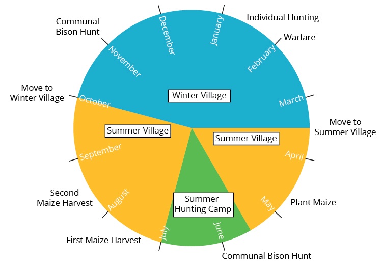
In May or June, the Illini abandoned their summer villages for the bison hunt, which both men and women participated in. Men hunted, women processed the meat. They established temporary camps in the prairie of bark-covered lodges where they would live during the hunt. In July, they returned to their summer villages to harvest crops. After the fall harvest in October, summer villages divided into smaller groups and lived in winter villages until April. They established these smaller villages in river bottoms where hunting was most plentiful in the winter.70
There was a pattern to the migration of Indian groups: they responded to the seasonal variation of nature. A crucial trait of the temperate Midwestern ecosystem is its periodicity. Flowers bloom in the spring, deciduous trees shed their leaves in the fall, plants move energy to their roots in the winter, birds migrate south in the fall and north in the spring, and many animals have a mating season. Animals, including humans, rely on both plants and other animals for food, so their subsistence strategy is shaped by the seasonal cycles of other species. A fox feeds on fruit and insects in the summer and rodents and birds in the winter. Bears are active in the spring and summer and hibernate beginning in the fall when their food becomes scarce.71 In much the same way, Illinois Indians migrated to where food was most plentiful that time of year.72
This seasonal migration was crucial to maintaining ecological balance. By relying on a variety of habitats when they were most plentiful, Indians ensured that they did not overuse any one particular species or part of the ecosystem. The Illini village breaking up into smaller groups for the winter was also an ecological strategy; having fewer people to feed across a larger resource base was ideal during the lean winter. Their society changed depending on ecological needs; a system that matched the mosaic of nature.73
Human impact was, of course, greatest near their settlements and camps where the most food was gathered, the most garbage was accumulated, and the most firewood burned. Indian corn fields still reduced the soil’s fertility just as Anglo-American fields would. Unlike white settlers though, New England Indians did not occupy the same settlements once their fields and forests were depleted. Instead, they abandoned crop sites after about a decade of planting and established new fields elsewhere.74 It is less clear if the Illini or Kickapoo did the same. Their summer villages were reoccupied every year, but it is difficult to determine for how long. It is even less clear whether winter villages or camps were reoccupied every year or if they changed locations.75 Regardless, both societies were clearly capable of migration, already migrating every year to where resources were most available. If one of their villages had depleted the resources of the area, likely they would abandon the site to form a new village elsewhere.
This mobility was crucial to mitigating human impact on nature. If hunting or gathering sufficiently reduced the numbers of any one animal or plant species in a particular area, Indians simply moved to rely on a different resource until the population recovered. Having such a diverse and wide resource base encouraged Indians to maintain ecological diversity.76
This lifestyle further encouraged relatively small populations. Upon European contact in the 1600s, the entire Illinois Confederacy of twelve tribes was made up of about 10,000 people, spread throughout much of what would become Illinois.77 In comparison, the American population in Illinois in 1810 was 12,282, the majority having arrived or been born that decade, and were largely concentrated in the American Bottom and other towns in southern Illinois. The white population would skyrocket shortly thereafter to 55,211 in 1820 and 269,974 in 1835.78 Today, Illinois is home to 12.8 million.79 Inevitably, a smaller population of Indians meant less human impact on the environment.
The American Bottom was hardly a pristine, unchanging wilderness when William B. Whiteside arrived in the 1790s. Nor was it one when the first European explorers Marquette and Joliet came in the 1670s. The St. Louis region was the product of thousands of years of natural and human-induced changes, changes coming from glaciers, rivers, the global climate, and human deforestation, hunting, and fires, along with many others.
Still, on the whole Native Americans before the arrival of Europeans brought fewer changes to the land than humans would after European arrival, for a variety of reasons. In general, Indian cultures encouraged respect towards the natural world and did not emphasize a strong distinction between humans and other animals. Their relatively low populations and little social pressure to seek material wealth limited the strain on natural resources. As Father Hennepin observed, the Miami only hunted bison once a year, for they obtained all they needed for the year in one hunt. With only an annual hunt, bison thrived.
Indian mobility further reduced their impact. Instead of wasting one particular resource in one particular area, Indians moved to where resources were most available that time of year. Thus Indians were like many natural predators; they kept the numbers of their “prey” reasonable without reducing them entirely.
Yet for a time an Indian group did overuse resources: Cahokia. The delicate balance between humans and nature tipped, and Cahokians transformed much of the American Bottom into crop land. Erosion and flooding became more frequent. In some ways, Cahokia’s natural imbalance foreshadowed the similar imbalance of white settlers would bring. Both groups were sedentary with denser populations, concentrating and exacerbating human impact. Both deforested the American Bottom and surrounding bluffs, leading to erosion.
Still, we must be careful to draw too many similarities between Cahokia and settlers of Whiteside’s era. For one thing, their cultures were vastly different. Anglo-Americans had a variety of domesticated animals, most notably cattle and pigs. Cahokians only had dogs.80 While trade was critical to Cahokia’s economy, it did not reach the magnitude of market capitalism that developed in Whiteside’s time. We have little reason to think Cahokians commoditized furs or trees the way Whiteside did. Both livestock and market capitalism played a large role in how Anglo-Americans transformed the American Bottom ecosystem.
Most importantly though, we must remember that Indians were not incapable of changing their natural surroundings, even if it was to a lesser extent than later settlers. In fact, they would begin to change the ecosystem when the French arrived and transformed Indian economies. With the French fur trade, Indians were incentivized to hunt more than they had before the French. For more on the transformations that came from the fur trade, see Arrival Materialism.
For how Whiteside and his fellow settlers first reacted to this natural landscape, see Arrival Ideology.
1. Andrew Hurley, “Common Fields: An Introduction,” in Common Fields: an environmental history of St. Louis, ed. Andrew Hurley. (St. Louis: Missouri Historical Society Press, 1997), 1 - 2.
2. William Cronon, Changes in the Land: Indians, Colonists, and the Ecology of New England. (New York: Hill and Wang, 1983), 11.
3. Walter Schroeder, “Environmental Setting of St. Louis,” in Common Fields, 33 - 34.
4. Cronon, Changes in the Land, 12.
7. Ibid., 23 - 24.
8. James E. Davis, Frontier Illinois. (Bloomington: Indiana University Press, 1998), 12 - 13.
9. Schroeder, 24 - 25.
10. Ibid., 25.
11 Ibid., 24 - 25; William R. Iseminger, “Culture and Environment in the American Bottom: The Rise and Fall of Cahokia Mounds,” in Common Fields, 39.
12. Iseminger, 39.
13. Schroeder, 26; F. Terry Norris, “Where Did the Villages Go: Steamboats, Deforestation, and Archaeological Loss in the Mississippi Valley,” in Common Fields, 81.
14. Schroeder, 34.
15. Likely the most extensive discussion of man-made climate change is the fifth report of the Intergovernmental Panel on Climate Change. IPCC, “Climate Change 2014: Synthesis Report,” Contribution of Working Groups I, II and III to the Fifth Assessment Report of the Intergovernmental Panel on Climate Change [Core Writing Team, R.K. Pachauri and L.A. Meyer (eds.)]. (Geneva, Switzerland: IPCC, 2014).
16. Schroeder, 36; Cronon, Changes in the Land, 33.
17. John M. Coggeshall, “Ethnic Persistence With Modification: the German-Americans of Southwestern Illinois” (Ph.D. dissertation, Southern Illinois University Carbondale, 1984), 60 - 64; Iseminger, 39.
18. Coggeshall, 63; Iseminger, 31 and 39.
20. Tim O’Neil, “A Look Back: When the Mississippi River froze over,” St. Louis Post-Dispatch, February 6, 2011, accessed September 5, 2016. I did not hear this testimony directly from my great-grandmother; my mother remembers her parents telling her.
22. Coggeshall, 65.
23. William Cronon, Nature’s Metropolis: Chicago and the Great West. (New York: W.W. Norton & Company, 1991), 98 - 99.
24. Donald F. Hoffmeister, Mammals of Illinois (Champaign: University of Illinois Press, 2002), XIII; Barry Yeoman, “Why the Passenger Pigeon Went Extinct” Audubon, May - June 2014.
25. “Bison Return to Nachusa,” The Nature Conservancy, accessed January 16, 2017.
26. The relative numbers of each of these species is based on personal experience rather than hard data, so its veracity should be taken with a grain of salt. For example, animals like bobcats are fairly common in Illinois but not often seen by humans.
28. Scholars still debate whether the extinction of these animals is more the result of the influx of humans into the Americas, known as the “overkill hypothesis,” or the end of the ice age. It is likely that humans at least played a part, though it is possible at least some of the animals would have gone extinct without humans. Schroeder, 21 - 34; Iseminger, 42; Bjorn Carey, “Humans Might Have Wiped Out Wild Horses,” Live Science, March 1, 2006.
29. Karl Marx and Friedrich Engels, “First Premises of Materialist Method,” in The German Ideology, marxists.org, accessed March 25, 2017. Written in 1845 - 6, first published 1932.
31. Genetic Science Learning Center, "Evolution of Corn." Learn.Genetics. July 1, 2013. Accessed September 5, 2016.
33. “Ten Largest Cities by Population, 1700–2000”; “Explore Cahokia Mounds,” Cahokia Mounds State Historic Site, accessed January 16, 2017.
34. 1086 was the year of the Domesday Book, in which London had a population of 18,000. Tim Lambert, “History of English Population,” A World History Encyclopedia. Revised 2015. Accessed September 5, 2016.
42. Paul Kilburn and Richard Brugam, "How Natural Is Nature? The Effect of Burning on Presettlement Vegetation in West-Central Illinois." The Confluence, Spring/Summer 2010 (2010), 42; “Prairie Peninsula,” Illinois State Museum, accessed March 15, 2017.
43. Kilburn and Brugam, 45.
44. Ibid., 44.
45. Ibid.
46. Ibid., 49.
47. Ibid., 49 - 50.
48. Ibid., 48.
49. Ibid., 51.
50. Cronon, Changes in the Land, 49 - 51.
51. Kilburn and Brugam, 45.
52. John Mack Faragher, Sugar Creek: Life on the Illinois Prairie. (New Haven: Yale University Press, 1986), 13 - 14.
53. Robert E. Warren, “Illinois Indians in the Illinois Country.” Illinois History Teacher 11:1 (2004), 21.
54. “Manitou,” Illinois State Museum, accessed March 15, 2017.
55. “Piasa,” Illinois State Museum, accessed March 15, 2017.
60. William Jones, Kickapoo Tales. (Leyden: E.J. Brill, 1915), 57 and 103.
62. “Folklore,” Illinois State Museum, accessed March 15, 2017.
65. Marshall Sahlins, Stone Age Economics. (Chicago: Aldine, 1972), 14.
68. Charles Callender, Richard K. Pope, Susan M. Pope, “Kickapoo” in Handbook of North American Indians Volume 15: Northeast, ed. Bruce G. Trigger. (Washington: Smithsonian Institution, 1978), 658.
69 Warren, 20; Callender, Pope, Pope; Charles Callender, “Illinois” in Handbook of North American Indians Volume 15: Northeast, 674 - 675.
71. “5 Stages of Activity and Hibernation,” North American Bear Center, accessed March 15, 2017.
72. Cronon, Changes in the Land, 37.
73. Ibid., 38 and 53; Duane E. Esarey, “Seasonal Occupation Patterns in Illinois History: A Case Study in the Lower Illinois River Valley.” Illinois Archaeology 9 (1997), 183.
74. Cronon, Changes in the Land, 45.
75. Esarey, 184.
76. Cronon, Changes in the Land, 53.
79. “QuickFacts: Illinois,” United States Census Bureau, accessed March 15, 2017.
80. Iseminger, 44.
Made with Bootstrap and Glyphicons.
Borderlands: The Goshen Settlement of William Bolin Whiteside by Ben Ostermeier is licensed under a Creative Commons Attribution-NonCommercial-ShareAlike 4.0 International License.